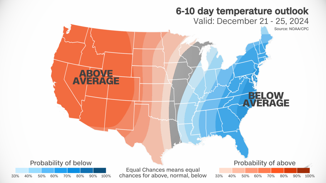
As Christmas draws near, many in the United States dreaming of a picturesque, snow-covered holiday may find themselves disappointed. Early forecasts suggest that temperatures across much of the country will be 10 to 15 degrees above average on Christmas Day, a pattern that mirrors last year’s unseasonably warm winter, the warmest on record in the U.S.
However, the country could see a sharp divide between warmth and cold leading up to the festive season. Unusually mild conditions are expected to dominate the western U.S., including Alaska and Hawaii, while much of the East will experience colder-than-usual weather in the days before Christmas, according to the Climate Prediction Center.
Christmas Weather Forecast: Snow Dreams or a Mild Holiday?
In Washington, DC, temperatures could struggle to stay below freezing from Sunday through Tuesday, before a modest rebound into the 40s on Christmas Day, which this year also marks the start of Hanukkah.
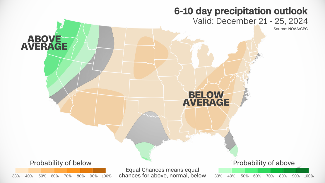
While colder weather is expected for much of the East, it’s likely to be drier than usual from next weekend through the holiday. The National Weather Service predicts that the Lower 48 states will experience unusual dryness, a situation that spells bad news for those hoping for a white Christmas.
Although it’s still too early to pinpoint exact conditions, some areas might still hold out hope. Early forecasts suggest a mix of rain and snow could impact high-elevation regions in the Northeast on Christmas Day, with a few snowflakes possibly drifting over parts of the Rockies. However, with weather patterns still evolving, these scenarios remain highly tentative, and shifts in the forecast over the coming days could alter the holiday outlook.
What Makes a White Christmas?
To qualify as a white Christmas, there needs to be at least 1 inch of snow on the ground on December 25. It doesn’t have to fall on the day itself — the snow just has to be there. Flurries that melt upon contact with the ground don’t count. However, if there’s a thick layer of snow left over from several large lake-effect storms, even if it’s not actively snowing on Christmas Day, that qualifies as a true white Christmas.
Currently, areas like the mountains of the West, parts of Michigan, New York, and northern New England likely have enough snow on the ground to ensure at least an inch remains through the holiday.
Historical Chances of a White Christmas
Even with typical weather, the likelihood of a white Christmas is limited to certain parts of the U.S. The north-central states — including the Dakotas, Minnesota, and Wisconsin — as well as mountainous regions in the West and Northeast, are the most likely to see snow on Christmas Day. This is because by late December, the north-central U.S. is usually cold enough to keep snow from melting, even with quick-moving storms common to the area in early winter.
In the mountainous regions, multiple snowfalls can build up a solid snowpack by Christmas, though this often happens only in the higher elevations where fewer people live.
If you want a white Christmas in a city setting, your best bets historically are Minneapolis – about a 70% chance — or Burlington, Vermont — around a 60 to 65% chance.
The Chicago area has about a 35 to 40% chance of a white Christmas each year while New York City and Philadelphia’s chances are an abysmal 10 to 15%.
Chicago and Minneapolis last had a white Christmas in 2022, but New York City, Philadelphia and Washington, DC, haven’t experienced one since 2009.
Atlanta and much of the South have about a 1% chance or lower of seeing a white Christmas.








Leave a comment